
Make a donation
Gear up for your next adventure:
As an Amazon Associate, this site earns from qualifying purchases at no extra cost to you.
Skövde topographic map
Click on the map to display elevation.
Make a donation
Gear up for your next adventure:
As an Amazon Associate, this site earns from qualifying purchases at no extra cost to you.
Skövde
Skövde has a maritime-continental hybrid climate. The town is influenced by being in the slope of a hill, which leads to warmer overnight lows than in Skara on the western side of the same higher area. In July 2018, Skövde recorded a 22 °C (72 °F) mean during the 2018 European heat wave. This makes it one of the very few stations in Sweden to have met the Köppen definition of a hot summer at any point in recorded weather history. Even so, Skövde is not frequently warm during an average year. On average, summers are cooler than on the east coast of the country. This is due to strong low pressure systems from the North Atlantic bringing plenty of rainy days along with an elevation of 150 metres (490 ft). Skövde does still have a lower precipitation total than areas to its south such as Borås and areas in Halland that are affected even more by the maritime patterns.
Make a donation
Gear up for your next adventure:
As an Amazon Associate, this site earns from qualifying purchases at no extra cost to you.
About this map
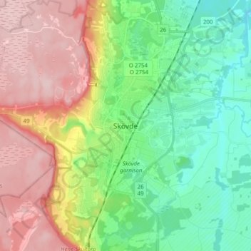
Name: Skövde topographic map, elevation, terrain.
Location: Skövde, Skövde kommun, Västra Götaland County, 541 30, Sweden (58.34963 13.80563 58.42963 13.88563)
Average elevation: 181 m
Minimum elevation: 98 m
Maximum elevation: 303 m
Make a donation
Gear up for your next adventure:
As an Amazon Associate, this site earns from qualifying purchases at no extra cost to you.
Other topographic maps
Click on a map to view its topography, its elevation and its terrain.
Make a donation
Gear up for your next adventure:
As an Amazon Associate, this site earns from qualifying purchases at no extra cost to you.
Make a donation
Gear up for your next adventure:
As an Amazon Associate, this site earns from qualifying purchases at no extra cost to you.
Make a donation
Gear up for your next adventure:
As an Amazon Associate, this site earns from qualifying purchases at no extra cost to you.
Make a donation
Gear up for your next adventure:
As an Amazon Associate, this site earns from qualifying purchases at no extra cost to you.
Make a donation
Gear up for your next adventure:
As an Amazon Associate, this site earns from qualifying purchases at no extra cost to you.
Make a donation
Gear up for your next adventure:
As an Amazon Associate, this site earns from qualifying purchases at no extra cost to you.
Make a donation
Gear up for your next adventure:
As an Amazon Associate, this site earns from qualifying purchases at no extra cost to you.
Make a donation
Gear up for your next adventure:
As an Amazon Associate, this site earns from qualifying purchases at no extra cost to you.
Make a donation
Gear up for your next adventure:
As an Amazon Associate, this site earns from qualifying purchases at no extra cost to you.
Make a donation
Gear up for your next adventure:
As an Amazon Associate, this site earns from qualifying purchases at no extra cost to you.
Make a donation
Gear up for your next adventure:
As an Amazon Associate, this site earns from qualifying purchases at no extra cost to you.
Make a donation
Gear up for your next adventure:
As an Amazon Associate, this site earns from qualifying purchases at no extra cost to you.