
Make a donation
Gear up for your next adventure:
As an Amazon Associate, this site earns from qualifying purchases at no extra cost to you.
Lichtenau topographic map
Click on the map to display elevation.
Make a donation
Gear up for your next adventure:
As an Amazon Associate, this site earns from qualifying purchases at no extra cost to you.
Lichtenau
Der tiefste Punkt des Stadtgebiets liegt mit etwa 172 m ü. NN bei Henglarn, der höchste ist der Schneefelder Berg mit 428 m ü. NN 1 km nordwestlich der Stadtwüstung Blankenrode. Die mittlere Höhe des gesamten Stadtgebiets beträgt etwa 205 m ü. NN.
Make a donation
Gear up for your next adventure:
As an Amazon Associate, this site earns from qualifying purchases at no extra cost to you.
About this map
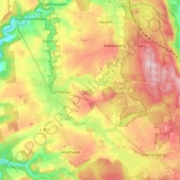
Name: Lichtenau topographic map, elevation, terrain.
Average elevation: 318 m
Minimum elevation: 204 m
Maximum elevation: 429 m
Make a donation
Gear up for your next adventure:
As an Amazon Associate, this site earns from qualifying purchases at no extra cost to you.