
Thank you for supporting this site ❤️
Make a donation
Make a donation
Gear up for your next adventure:
As an Amazon Associate, this site earns from qualifying purchases at no extra cost to you.
Oberstdorf topographic map
Click on the map to display elevation.
Thank you for supporting this site ❤️
Make a donation
Make a donation
Gear up for your next adventure:
As an Amazon Associate, this site earns from qualifying purchases at no extra cost to you.
About this map
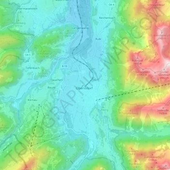
Name: Oberstdorf topographic map, elevation, terrain.
Location: Oberstdorf, Landkreis Oberallgäu, Beieren, 87561, Duitsland (47.37183 10.23810 47.45183 10.31810)
Average elevation: 1,098 m
Minimum elevation: 760 m
Maximum elevation: 2,099 m
Thank you for supporting this site ❤️
Make a donation
Make a donation
Gear up for your next adventure:
As an Amazon Associate, this site earns from qualifying purchases at no extra cost to you.