
Make a donation
Gear up for your next adventure:
As an Amazon Associate, this site earns from qualifying purchases at no extra cost to you.
Le Locle topographic map
Click on the map to display elevation.
Make a donation
Gear up for your next adventure:
As an Amazon Associate, this site earns from qualifying purchases at no extra cost to you.
Le Locle
Il territorio del comune di Le Locle, città situata a un'altitudine di 946 m s.l.m., si estende in una valle del massiccio del Giura, lungo il confine tra la Francia e la Svizzera; è limitato a ovest dal passo Col des Roches, a est da Le Crêt-du-Locle, frazione di La Chaux-de-Fonds.
Make a donation
Gear up for your next adventure:
As an Amazon Associate, this site earns from qualifying purchases at no extra cost to you.
About this map
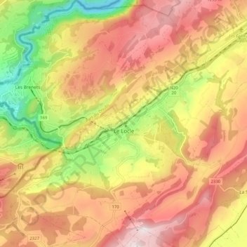
Name: Le Locle topographic map, elevation, terrain.
Location: Le Locle, Neuchâtel, 2400, Svizzera (47.02311 6.69151 47.09199 6.78686)
Average elevation: 1,050 m
Minimum elevation: 697 m
Maximum elevation: 1,329 m
Make a donation
Gear up for your next adventure:
As an Amazon Associate, this site earns from qualifying purchases at no extra cost to you.