
Make a donation
Gear up for your next adventure:
As an Amazon Associate, this site earns from qualifying purchases at no extra cost to you.
Fuchskaute topographic map
Click on the map to display elevation.
Make a donation
Gear up for your next adventure:
As an Amazon Associate, this site earns from qualifying purchases at no extra cost to you.
Fuchskaute
Die Fuchskaute hat zwei etwa 650 m voneinander entfernte Kuppen – mit Höhen in Meter (m) über Normalhöhennull (NHN): die auch Alteberg genannte Nordkuppe (656,4 m) und die Südkuppe (657,3 m), wobei sich letztere in zwei rund 175 m auseinander liegende Anhöhen aufteilt, nämlich in die Nordanhöhe (657,3 m) und die Südanhöhe (656,5 m).
Make a donation
Gear up for your next adventure:
As an Amazon Associate, this site earns from qualifying purchases at no extra cost to you.
About this map
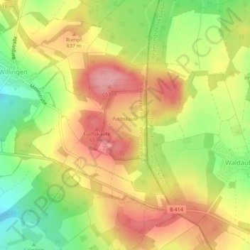
Name: Fuchskaute topographic map, elevation, terrain.
Average elevation: 609 m
Minimum elevation: 541 m
Maximum elevation: 665 m
Make a donation
Gear up for your next adventure:
As an Amazon Associate, this site earns from qualifying purchases at no extra cost to you.