
Make a donation
Gear up for your next adventure:
As an Amazon Associate, this site earns from qualifying purchases at no extra cost to you.
Xi'an topographic map
Click on the map to display elevation.
Make a donation
Gear up for your next adventure:
As an Amazon Associate, this site earns from qualifying purchases at no extra cost to you.
Xi'an
Xi'an lies on the Guanzhong Plain in the south-central part of Shaanxi province, on a flood plain created by the eight surrounding rivers and streams. The city has an average elevation of 400 metres (1,312 ft) above sea level and an annual precipitation of 553 mm (21.8 in). The urban area of Xi'an is located at 34°16′N 108°56′E / 34.267°N 108.933°E / 34.267; 108.933. The Wei River provides potable water to the city.
Make a donation
Gear up for your next adventure:
As an Amazon Associate, this site earns from qualifying purchases at no extra cost to you.
About this map
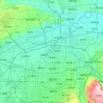
Name: Xi'an topographic map, elevation, terrain.
Location: Xi'an, Weiyang District, Xi'an, Shaanxi, 710018, China (34.18305 108.77508 34.50305 109.09508)
Average elevation: 412 m
Minimum elevation: 350 m
Maximum elevation: 778 m
Make a donation
Gear up for your next adventure:
As an Amazon Associate, this site earns from qualifying purchases at no extra cost to you.