
Make a donation
Gear up for your next adventure:
As an Amazon Associate, this site earns from qualifying purchases at no extra cost to you.
Piers Island topographic map
Click on the map to display elevation.
Make a donation
Gear up for your next adventure:
As an Amazon Associate, this site earns from qualifying purchases at no extra cost to you.
About this map
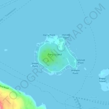
Name: Piers Island topographic map, elevation, terrain.
Average elevation: 4 m
Minimum elevation: 0 m
Maximum elevation: 101 m
Make a donation
Gear up for your next adventure:
As an Amazon Associate, this site earns from qualifying purchases at no extra cost to you.
Other topographic maps
Click on a map to view its topography, its elevation and its terrain.
Mayne
Canada > British Columbia > Capital Regional District > Southern Gulf Islands Electoral Area
Average elevation: 52 m
Mount Parke
Canada > British Columbia > Capital Regional District > Southern Gulf Islands Electoral Area
Average elevation: 74 m
Mayne
Canada > British Columbia > Capital Regional District > Southern Gulf Islands Electoral Area
Average elevation: 52 m
Mayne
Canada > British Columbia > Capital Regional District > Southern Gulf Islands Electoral Area
Average elevation: 52 m
Make a donation
Gear up for your next adventure:
As an Amazon Associate, this site earns from qualifying purchases at no extra cost to you.