
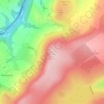
Stoodley Pike topographic map
Interactive map
Click on the map to display elevation.
About this map
Name: Stoodley Pike topographic map, elevation, terrain.
Average elevation: 291 m
Minimum elevation: 115 m
Maximum elevation: 405 m
Other topographic maps
Click on a map to view its topography, its elevation and its terrain.
Hebden Bridge
United Kingdom > England > Calderdale
Hebden Bridge, Calderdale, West Yorkshire, England, HX7 8AT, United Kingdom
Average elevation: 277 m
Todmorden
United Kingdom > England > Calderdale
Todmorden, Calderdale, West Yorkshire, England, United Kingdom
Average elevation: 311 m
Halifax
United Kingdom > England > Calderdale
Halifax, Calderdale, West Yorkshire, England, HX1 1TH, United Kingdom
Average elevation: 195 m
Lower Edge
United Kingdom > England > Calderdale > Upper Edge
Lower Edge, Upper Edge, Calderdale, West Yorkshire, England, HX5 9QB, United Kingdom
Average elevation: 141 m
Holdsworth
United Kingdom > England > Calderdale
Holdsworth, Calderdale, West Yorkshire, England, HX2 9TF, United Kingdom
Average elevation: 273 m
Brookfoot
United Kingdom > England > Calderdale > Brighouse
Brookfoot, Brighouse, Calderdale, West Yorkshire, England, HD6 2RB, United Kingdom
Average elevation: 113 m
Hipperholme
United Kingdom > England > Calderdale
Hipperholme, Calderdale, West Yorkshire, England, HX3 8NA, United Kingdom
Average elevation: 164 m
Calder & Hebble Navigation Halifax Cut
United Kingdom > England > Calderdale > Skircoat Green
Calder & Hebble Navigation Halifax Cut, Salterhebble, Skircoat Green, Calderdale, West Yorkshire, England, HX3 0QT, United Kingdom
Average elevation: 136 m
Norland Town
United Kingdom > England > Calderdale > Norland
Norland Town, Norland, Calderdale, West Yorkshire, England, HX6 3QZ, United Kingdom
Average elevation: 172 m
Lane Ends
United Kingdom > England > Calderdale > Stump Cross > Shibden Dale
Lane Ends, Shibden Dale, Stump Cross, Calderdale, West Yorkshire, England, HX3 7UW, United Kingdom
Average elevation: 221 m
Colden Water
United Kingdom > England > Calderdale > Heptonstall
Colden Water, Heptonstall, Mytholm, Calderdale, West Yorkshire, England, HX7 6DF, United Kingdom
Average elevation: 226 m
Blackshaw Head
United Kingdom > England > Calderdale
Blackshaw Head, Calderdale, West Yorkshire, England, HX7 7JF, United Kingdom
Average elevation: 310 m
Top Shelf
United Kingdom > England > Calderdale > Shelf
Top Shelf, Shelf, Calderdale, West Yorkshire, England, HX3 7RJ, United Kingdom
Average elevation: 241 m
Brighouse
United Kingdom > England > Calderdale
Brighouse, Calderdale, West Yorkshire, England, HD6 1AX, United Kingdom
Average elevation: 134 m
Cross Stone
United Kingdom > England > Calderdale > Todmorden
Cross Stone, Todmorden, Calderdale, West Yorkshire, England, OL14 8AX, United Kingdom
Average elevation: 245 m
Sowerby Bridge
United Kingdom > England > Calderdale
Sowerby Bridge, Calderdale, West Yorkshire, England, HX6 2EH, United Kingdom
Average elevation: 200 m
Stump Cross
United Kingdom > England > Calderdale
Stump Cross, Calderdale, West Yorkshire, England, HX3 7AX, United Kingdom
Average elevation: 198 m
Edge End Moor
United Kingdom > England > Calderdale > Mytholm
Edge End Moor, Erringden, Mytholm, Calderdale, West Yorkshire, England, United Kingdom
Average elevation: 251 m
Bank Top
United Kingdom > England > Calderdale
Bank Top, Calderdale, West Yorkshire, England, HX3 9NG, United Kingdom
Average elevation: 162 m
Old Town
United Kingdom > England > Calderdale
Old Town, Calderdale, West Yorkshire, England, HX7 8FE, United Kingdom
Average elevation: 268 m
Northowram
United Kingdom > England > Calderdale
Northowram, Calderdale, West Yorkshire, England, HX3 7EB, United Kingdom
Average elevation: 209 m
Warland
United Kingdom > England > Calderdale > Todmorden
Warland, Todmorden, Calderdale, West Yorkshire, England, OL14 6UZ, United Kingdom
Average elevation: 306 m
Cornholme
United Kingdom > England > Calderdale
Cornholme, Calderdale, West Yorkshire, England, OL14 8LS, United Kingdom
Average elevation: 325 m
Warley Town
United Kingdom > England > Calderdale
Warley Town, Calderdale, West Yorkshire, England, HX2 7SA, United Kingdom
Average elevation: 193 m
Colden
United Kingdom > England > Calderdale > Heptonstall
Colden, Heptonstall, Blackshaw Head, Calderdale, West Yorkshire, England, HX7 7PF, United Kingdom
Average elevation: 305 m
Shelf
United Kingdom > England > Calderdale
Shelf, Calderdale, West Yorkshire, England, HX3 7NB, United Kingdom
Average elevation: 246 m
Mytholmroyd
United Kingdom > England > Calderdale
Mytholmroyd, Calderdale, West Yorkshire, England, HX7 5DU, United Kingdom
Average elevation: 224 m
Heptonstall
United Kingdom > England > Calderdale
Heptonstall, Calderdale, West Yorkshire, England, United Kingdom
Average elevation: 329 m
Ripponden
United Kingdom > England > Calderdale
Ripponden, Calderdale, West Yorkshire, England, United Kingdom
Average elevation: 285 m
Southowram
United Kingdom > England > Calderdale
Southowram, Calderdale, West Yorkshire, England, HX3 9RS, United Kingdom
Average elevation: 142 m
Birchcliffe
United Kingdom > England > Calderdale > Hebden Bridge
Birchcliffe, Hebden Royd, Hebden Bridge, Calderdale, West Yorkshire, England, HX7 8DB, United Kingdom
Average elevation: 239 m
Ainley Top
United Kingdom > England > Calderdale
Ainley Top, Calderdale, West Yorkshire, England, HD2 2EE, United Kingdom
Average elevation: 174 m
Gaddings Dam
United Kingdom > England > Calderdale > Todmorden > Walsden
Gaddings Dam, Todmorden, Walsden, Calderdale, West Yorkshire, England, OL14 6HT, United Kingdom
Average elevation: 282 m
Ripponden
United Kingdom > England > Calderdale > Ripponden
Ripponden, Calderdale, West Yorkshire, Yorkshire and the Humber, England, HX6, United Kingdom
Average elevation: 259 m
Boulderclough
United Kingdom > England > Calderdale > Luddendenfoot
Boulderclough, Luddendenfoot, Calderdale, West Yorkshire, England, HX6 1NQ, United Kingdom
Average elevation: 214 m
Elland
United Kingdom > England > Calderdale
Elland, Calderdale, West Yorkshire, England, HX5 0DE, United Kingdom
Average elevation: 163 m
Exley
United Kingdom > England > Calderdale > West Vale
Exley, West Vale, Calderdale, West Yorkshire, England, HX3 9EF, United Kingdom
Average elevation: 138 m
Akroydon
United Kingdom > England > Calderdale > Halifax > Akroydon
Akroydon, Halifax, Calderdale, West Yorkshire, Yorkshire and the Humber, England, HX3 6LS, United Kingdom
Average elevation: 210 m
Lightcliffe
United Kingdom > England > Calderdale > Hipperholme
Lightcliffe, Hipperholme, Calderdale, West Yorkshire, England, HX3 8UE, United Kingdom
Average elevation: 146 m
Mankinholes
United Kingdom > England > Calderdale > Todmorden > Mankinholes
Mankinholes, Todmorden, Calderdale, West Yorkshire, Yorkshire and the Humber, England, OL14 6HR, United Kingdom
Average elevation: 281 m
Stone Chair
United Kingdom > England > Calderdale > Shelf > Stone Chair
Stone Chair, Shelf, Calderdale, West Yorkshire, Yorkshire and the Humber, England, HX3 7LF, United Kingdom
Average elevation: 226 m
Ringstone Edge Moor
United Kingdom > England > Calderdale > Ripponden
Ringstone Edge Moor, Ripponden, Calderdale, West Yorkshire, Yorkshire and the Humber, England, HX6, United Kingdom
Average elevation: 243 m
Shibden Park
United Kingdom > England > Calderdale > Stump Cross
Shibden Park, Claremount, Stump Cross, Calderdale, West Yorkshire, Yorkshire and the Humber, England, United Kingdom
Average elevation: 183 m
Cragg Vale
United Kingdom > England > Calderdale
Cragg Vale, Calderdale, West Yorkshire, England, HX7 5TG, United Kingdom
Average elevation: 299 m
Brearley
United Kingdom > England > Calderdale > Brearley
Brearley, Calderdale, Yorkshire and the Humber, England, HX2 6HU, United Kingdom
Average elevation: 213 m
Calder & Hebble Navigation
United Kingdom > England > Calderdale
Calder & Hebble Navigation, Calderdale, Yorkshire and the Humber, England, HD6 1PS, United Kingdom
Average elevation: 95 m
Clough Head
United Kingdom > England > Calderdale > Norland
Clough Head, Norland, Calderdale, West Yorkshire, England, HX6 3QR, United Kingdom
Average elevation: 174 m
Blackshaw Head
United Kingdom > England > Calderdale
Blackshaw Head, Blackshaw, Calderdale, West Yorkshire, England, United Kingdom
Average elevation: 315 m
Holywell Green
United Kingdom > England > Calderdale
Holywell Green, Calderdale, West Yorkshire, England, HX4 9AT, United Kingdom
Average elevation: 180 m
Hebden Royd
United Kingdom > England > Calderdale
Hebden Royd, Calderdale, Yorkshire and the Humber, England, United Kingdom
Average elevation: 271 m