
Make a donation
Gear up for your next adventure:
As an Amazon Associate, this site earns from qualifying purchases at no extra cost to you.
Taungoo topographic map
Click on the map to display elevation.
Make a donation
Gear up for your next adventure:
As an Amazon Associate, this site earns from qualifying purchases at no extra cost to you.
Taungoo
Three mountain ranges traverse the district—the Pegu Yomas, the Karen Hills, and the Nat Ma Taung or "Great Watershed"—all of which have a north and south direction, and are covered for the most part with dense forest. The Pegu Yomas have a general elevation of from 800 to 1,200 feet (240 to 370 m), while the central range averages from 2,000 to 3,000 feet (610 to 910 m). The rest of Taungoo forms the upper portion of the valley of the Sittaung River.
Make a donation
Gear up for your next adventure:
As an Amazon Associate, this site earns from qualifying purchases at no extra cost to you.
About this map
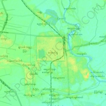
Name: Taungoo topographic map, elevation, terrain.
Location: Taungoo, Taungoo Township, Taungoo District, 08101, Myanmar (18.90021 96.39328 18.98021 96.47328)
Average elevation: 47 m
Minimum elevation: 38 m
Maximum elevation: 62 m
Make a donation
Gear up for your next adventure:
As an Amazon Associate, this site earns from qualifying purchases at no extra cost to you.