
Rahačoŭ District topographic map
Interactive map
Click on the map to display elevation.
About this map
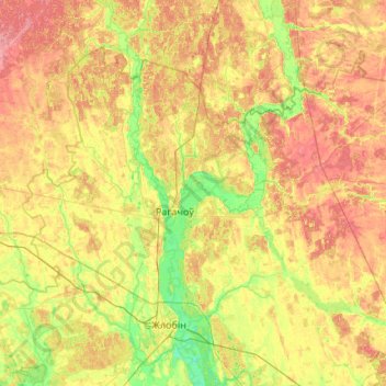
Name: Rahačoŭ District topographic map, elevation, terrain.
Location: Rahačoŭ District, Homyel Region, Belarus (52.86546 29.62844 53.35510 30.70094)
Average elevation: 146 m
Minimum elevation: 120 m
Maximum elevation: 180 m
Other topographic maps
Click on a map to view its topography, its elevation and its terrain.
Rahachow
Belarus > Homyel Region > Rahachow
Rahachow, Rahačoŭ District, Homyel Region, Belarus
Average elevation: 135 m
Тихиничи
Belarus > Homyel Region > Узовский сельский Совет > Тихиничи
Тихиничи, Узовский сельский Совет, Buda-Kashalyova District, Homyel Region, Belarus
Average elevation: 136 m