
Make a donation
Gear up for your next adventure:
As an Amazon Associate, this site earns from qualifying purchases at no extra cost to you.
Langenbach topographic map
Click on the map to display elevation.
Make a donation
Gear up for your next adventure:
As an Amazon Associate, this site earns from qualifying purchases at no extra cost to you.
About this map
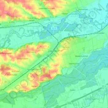
Name: Langenbach topographic map, elevation, terrain.
Location: Langenbach, Landkreis Freising, Bayern, 85416, Deutschland (48.41218 11.79540 48.45700 11.91161)
Average elevation: 438 m
Minimum elevation: 409 m
Maximum elevation: 504 m
Make a donation
Gear up for your next adventure:
As an Amazon Associate, this site earns from qualifying purchases at no extra cost to you.
Other topographic maps
Click on a map to view its topography, its elevation and its terrain.
Make a donation
Gear up for your next adventure:
As an Amazon Associate, this site earns from qualifying purchases at no extra cost to you.
Make a donation
Gear up for your next adventure:
As an Amazon Associate, this site earns from qualifying purchases at no extra cost to you.
Make a donation
Gear up for your next adventure:
As an Amazon Associate, this site earns from qualifying purchases at no extra cost to you.
Xaverienthal
Deutschland > Bayern > Landkreis Freising > Freising > Altenhausen
Average elevation: 469 m
Make a donation
Gear up for your next adventure:
As an Amazon Associate, this site earns from qualifying purchases at no extra cost to you.
Make a donation
Gear up for your next adventure:
As an Amazon Associate, this site earns from qualifying purchases at no extra cost to you.
Make a donation
Gear up for your next adventure:
As an Amazon Associate, this site earns from qualifying purchases at no extra cost to you.
Make a donation
Gear up for your next adventure:
As an Amazon Associate, this site earns from qualifying purchases at no extra cost to you.
Make a donation
Gear up for your next adventure:
As an Amazon Associate, this site earns from qualifying purchases at no extra cost to you.
Kammerberg
Deutschland > Bayern > Landkreis Freising
Das „Bürger Windrad Kammerberg“ ist ein Windrad vom Typ Enercon E-115 mit 149 Meter Nabenhöhe und einer Gesamthöhe von 207 Meter. Es wird betrieben von der Bürger Energie Genossenschaft – Freisinger Land eG. Es gibt noch Pläne für weitere Windräderturme zu bauen.
Average elevation: 485 m
Troll
Deutschland > Bayern > Landkreis Freising > Moosburg
Auf alten topografischen Karten von 1890 befindet sich die Bezeichnung „Trollmühle“, die 1943 durch „Troll“ ersetzt wurde. Bis zum 1. Januar 1978 war Troll ein Ortsteil von Pfrombach, das dann nach Moosburg eingemeindet wurde.
Average elevation: 425 m
Make a donation
Gear up for your next adventure:
As an Amazon Associate, this site earns from qualifying purchases at no extra cost to you.
Isar-Amper-Überleitungskanal
Deutschland > Bayern > Landkreis Freising > Moosburg > Thonstetten
Average elevation: 418 m
Make a donation
Gear up for your next adventure:
As an Amazon Associate, this site earns from qualifying purchases at no extra cost to you.
Make a donation
Gear up for your next adventure:
As an Amazon Associate, this site earns from qualifying purchases at no extra cost to you.
Make a donation
Gear up for your next adventure:
As an Amazon Associate, this site earns from qualifying purchases at no extra cost to you.
Make a donation
Gear up for your next adventure:
As an Amazon Associate, this site earns from qualifying purchases at no extra cost to you.