Geolocate

Ightham Common topographic map

Click on the map to display elevation.

About this map
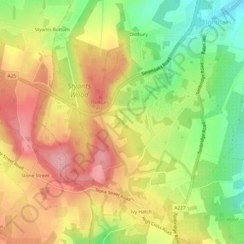
Name: Ightham Common topographic map, elevation, terrain.

Location: Ightham Common, Ightham, Tonbridge and Malling, Kent, England, TN15 9DU, United Kingdom (51.26624 0.26044 51.28624 0.28044)

Average elevation: 145 m

Minimum elevation: 77 m

Maximum elevation: 204 m

Other topographic maps

Click on a map to view its topography, its elevation and its terrain.
Ightham

United Kingdom > England > Kent > Tonbridge and Malling > Ightham

Average elevation: 121 m

Gear up for your next adventure:

📍Handheld GPS Devices - Accurate GPS units for mapping and navigation
🌄Sun Protection Gear - Gear to shield from strong sun
💡Hiking Headlamps - Hands‑free lights for night hikes
🗺️Topographic Maps - Detailed maps for hiking, cycling and planning routes
🥾Women's Waterproof Boots - Gore-Tex protection for trail and mountain walking

As an Amazon Associate, this site earns from qualifying purchases at no extra cost to you.