
Make a donation
Gear up for your next adventure:
As an Amazon Associate, this site earns from qualifying purchases at no extra cost to you.
Asheboro topographic map
Click on the map to display elevation.
Make a donation
Gear up for your next adventure:
As an Amazon Associate, this site earns from qualifying purchases at no extra cost to you.
About this map
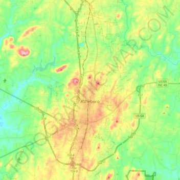
Name: Asheboro topographic map, elevation, terrain.
Location: Asheboro, Randolph County, North Carolina, United States (35.64477 -79.96995 35.79158 -79.76473)
Average elevation: 208 m
Minimum elevation: 130 m
Maximum elevation: 343 m
Make a donation
Gear up for your next adventure:
As an Amazon Associate, this site earns from qualifying purchases at no extra cost to you.
Other topographic maps
Click on a map to view its topography, its elevation and its terrain.
Make a donation
Gear up for your next adventure:
As an Amazon Associate, this site earns from qualifying purchases at no extra cost to you.
Redding Hills
United States > North Carolina > Randolph County > Asheboro > Redding Hills
Average elevation: 223 m