
Lowell topographic map
Interactive map
Click on the map to display elevation.
About this map
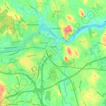
Name: Lowell topographic map, elevation, terrain.
Location: Lowell, Middlesex County, Massachusetts, United States (42.60649 -71.38248 42.66652 -71.27119)
Average elevation: 42 m
Minimum elevation: 14 m
Maximum elevation: 105 m
Lowell is located at the confluence of the Merrimack and Concord rivers. The Pawtucket Falls, a mile-long set of rapids with a total drop in elevation of 32 feet, ends where the two rivers meet. At the top of the falls is the Pawtucket Dam, designed to turn the upper Merrimack into a millpond, diverted through Lowell's extensive canal system.
Other topographic maps
Click on a map to view its topography, its elevation and its terrain.
Somerville
United States > Massachusetts > Middlesex County
Somerville, Middlesex County, Massachusetts, United States
Average elevation: 11 m
Medford
United States > Massachusetts > Middlesex County
Medford, Middlesex County, Massachusetts, 02155, United States
Average elevation: 23 m
Melrose
United States > Massachusetts > Middlesex County
Melrose, Middlesex County, Massachusetts, 02176, United States
Average elevation: 38 m
Lexington
United States > Massachusetts > Middlesex County
Lexington, Middlesex County, Massachusetts, United States
Average elevation: 62 m
Framingham
United States > Massachusetts > Middlesex County
Framingham, Middlesex County, Massachusetts, United States
Average elevation: 70 m
Marlborough
United States > Massachusetts > Middlesex County
Marlborough, Middlesex County, Massachusetts, United States
Average elevation: 95 m
Woburn
United States > Massachusetts > Middlesex County
Woburn, Middlesex County, Massachusetts, 01801, United States
Average elevation: 40 m
Winchester
United States > Massachusetts > Middlesex County
Winchester, Middlesex County, Massachusetts, 01890, United States
Average elevation: 38 m
Hopkinton
United States > Massachusetts > Middlesex County > Hopkinton
Hopkinton, Middlesex County, Massachusetts, 01748, United States
Average elevation: 109 m
Burlington
United States > Massachusetts > Middlesex County
Burlington, Middlesex County, Massachusetts, United States
Average elevation: 44 m
Fuller Heights
United States > Massachusetts > Middlesex County > Lexington
Fuller Heights, Lexington, Middlesex County, Massachusetts, 02420, United States
Average elevation: 66 m
Saxonville
United States > Massachusetts > Middlesex County > Framingham
Saxonville, Framingham, Middlesex County, Massachusetts, 01701, United States
Average elevation: 53 m
Acton
United States > Massachusetts > Middlesex County
Acton, Middlesex County, Massachusetts, United States
Average elevation: 66 m
Dracut
United States > Massachusetts > Middlesex County
Dracut, Middlesex County, Massachusetts, 01826, United States
Average elevation: 50 m
Pine Lake
United States > Massachusetts > Middlesex County > Sudbury
Pine Lake, Sudbury, Middlesex County, Massachusetts, 01776, United States
Average elevation: 61 m
Watertown
United States > Massachusetts > Middlesex County
Watertown, Middlesex County, Massachusetts, United States
Average elevation: 26 m
Groton
United States > Massachusetts > Middlesex County
Groton, Middlesex County, Massachusetts, 01450, United States
Average elevation: 85 m
Malden
United States > Massachusetts > Middlesex County
Malden, Middlesex County, Massachusetts, United States
Average elevation: 25 m
Musketamquid Village
United States > Massachusetts > Middlesex County > Sudbury
Musketamquid Village, Sudbury, Middlesex County, Massachusetts, 01776, United States
Average elevation: 58 m
North Woburn
United States > Massachusetts > Middlesex County > Woburn
North Woburn, Woburn, Middlesex County, Massachusetts, 01801, United States
Average elevation: 35 m
Holliston
United States > Massachusetts > Middlesex County
Holliston, Middlesex County, Massachusetts, 01746, United States
Average elevation: 72 m
Bedford
United States > Massachusetts > Middlesex County
Bedford, Middlesex County, Massachusetts, 01730, United States
Average elevation: 45 m
Billerica
United States > Massachusetts > Middlesex County
Billerica, Middlesex County, Massachusetts, United States
Average elevation: 47 m
Weston
United States > Massachusetts > Middlesex County
Weston, Middlesex County, Massachusetts, 02493, United States
Average elevation: 56 m
Lindenwood
United States > Massachusetts > Middlesex County > Stoneham
Lindenwood, Stoneham, Middlesex County, Massachusetts, 02180, United States
Average elevation: 38 m
Cambridge
United States > Massachusetts > Middlesex County
Cambridge, Middlesex County, Massachusetts, United States
Average elevation: 11 m
Waltham
United States > Massachusetts > Middlesex County
Waltham, Middlesex County, Massachusetts, United States
Average elevation: 48 m
Ashland
United States > Massachusetts > Middlesex County
Ashland, Middlesex County, Massachusetts, 01721, United States
Average elevation: 81 m
Waitts Mount
United States > Massachusetts > Middlesex County > Malden > Malden Centre
Waitts Mount, Malden Centre, Malden, Middlesex County, Massachusetts, United States
Average elevation: 22 m
Pepperell
United States > Massachusetts > Middlesex County
Pepperell, Middlesex County, Massachusetts, United States
Average elevation: 90 m
Reading Highlands
United States > Massachusetts > Middlesex County > Reading
Reading Highlands, Reading, Middlesex County, Massachusetts, 01867, United States
Average elevation: 34 m
Edgeworth
United States > Massachusetts > Middlesex County > Malden
Edgeworth, Malden, Middlesex County, Massachusetts, 02148, United States
Average elevation: 16 m
Dunstable
United States > Massachusetts > Middlesex County
Dunstable, Middlesex County, Massachusetts, 01879, United States, Nutting Hill
Average elevation: 60 m
Hudson
United States > Massachusetts > Middlesex County
Hudson, Middlesex County, Massachusetts, 01749, United States
Average elevation: 98 m
Riverside
United States > Massachusetts > Middlesex County > Billerica
Riverside, Billerica, Middlesex County, Massachusetts, 01741, United States
Average elevation: 53 m
Tyngsborough
United States > Massachusetts > Middlesex County
Tyngsborough, Middlesex County, Massachusetts, 01879, United States
Average elevation: 55 m
Stoneham
United States > Massachusetts > Middlesex County
Stoneham, Middlesex County, Massachusetts, 02180, United States
Average elevation: 40 m
Munroe Station
United States > Massachusetts > Middlesex County > Lexington
Munroe Station, Lexington, Middlesex County, Massachusetts, 02421, United States
Average elevation: 67 m
Liberty Heights
United States > Massachusetts > Middlesex County > Lexington
Liberty Heights, Lexington, Middlesex County, Massachusetts, 02476, United States
Average elevation: 70 m
Arlington
United States > Massachusetts > Middlesex County
Arlington, Middlesex County, Massachusetts, United States
Average elevation: 35 m
Everett
United States > Massachusetts > Middlesex County
Everett, Middlesex County, Massachusetts, 02149, United States
Average elevation: 12 m
Lake Mascuppic
United States > Massachusetts > Middlesex County > Tyngsborough > Willowdale
Lake Mascuppic, Willowdale, Tyngsborough, Middlesex County, Massachusetts, United States
Average elevation: 57 m
Chelmsford
United States > Massachusetts > Middlesex County
Chelmsford, Middlesex County, Massachusetts, United States
Average elevation: 52 m
Arlington Heights
United States > Massachusetts > Middlesex County > Arlington
Arlington Heights, Arlington, Middlesex County, Massachusetts, 02476, United States
Average elevation: 58 m
Winnmere
United States > Massachusetts > Middlesex County > Burlington
Winnmere, Burlington, Middlesex County, Massachusetts, 01801, United States
Average elevation: 46 m
Newton
United States > Massachusetts > Middlesex County > Newton
Newton, Middlesex County, Massachusetts, 02461, United States
Average elevation: 43 m
Boxborough
United States > Massachusetts > Middlesex County
Boxborough, Middlesex County, Massachusetts, 01719, United States
Average elevation: 98 m
Glenwood
United States > Massachusetts > Middlesex County > Medford
Glenwood, Medford, Middlesex County, Massachusetts, 02155, United States
Average elevation: 20 m
East Arlington
United States > Massachusetts > Middlesex County > Arlington
East Arlington, Arlington, Middlesex County, Massachusetts, 02475, United States
Average elevation: 15 m
Horn Pond Mountain
United States > Massachusetts > Middlesex County > Woburn
Horn Pond Mountain, Woburn, Middlesex County, Massachusetts, 01890, United States
Average elevation: 33 m