
Ruislip topographic map
Click on the map to display elevation.
About this map
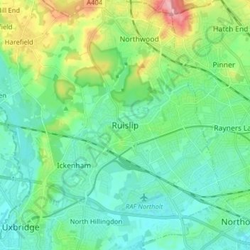
Name: Ruislip topographic map, elevation, terrain.
Location: Ruislip, Greater London, England, HA4 8BD, United Kingdom (51.53756 -0.46785 51.61756 -0.38785)
Average elevation: 54 m
Minimum elevation: 27 m
Maximum elevation: 137 m
Other topographic maps
Click on a map to view its topography, its elevation and its terrain.
London Borough of Richmond upon Thames
United Kingdom > England > Greater London
Average elevation: 18 m
Norwood Grove
United Kingdom > England > Greater London
After Anderson died, ownership passed to the Nettlefold family and subsequently to Frederick Nettlefold the brother of Joseph Nettlefold and a member of the family that founded the Nettlefolds Ltd. engineering firm which later became GKN. Nettlefold is commemorated, as a result of his charitable works, by a…
Average elevation: 58 m
Pymmes Brook
United Kingdom > England > Greater London
Prior to the Anglian glaciation, a "proto-Mole-Wey" river was flowing northwards from the Weald and North Downs, through the "Finchley depression" and Palmers Green, to join the proto-Thames somewhere around Hoddesdon, at what is today an altitude of around 60 metres. It was this river which, during the course…
Average elevation: 41 m