
Make a donation
Gear up for your next adventure:
As an Amazon Associate, this site earns from qualifying purchases at no extra cost to you.
Village of Rouses Point topographic map
Click on the map to display elevation.
Make a donation
Gear up for your next adventure:
As an Amazon Associate, this site earns from qualifying purchases at no extra cost to you.
About this map
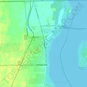
Name: Village of Rouses Point topographic map, elevation, terrain.
Average elevation: 35 m
Minimum elevation: 29 m
Maximum elevation: 49 m
Make a donation
Gear up for your next adventure:
As an Amazon Associate, this site earns from qualifying purchases at no extra cost to you.
Other topographic maps
Click on a map to view its topography, its elevation and its terrain.
Woods Mills
United States > New York > Clinton County > Town of Schuyler Falls
Average elevation: 211 m
Lake Roxanne
United States > New York > Clinton County > Town of Ellenburg > Ellenburg Depot
Average elevation: 280 m
Stevens Landing
United States > New York > Clinton County > Town of Black Brook
Average elevation: 385 m
Make a donation
Gear up for your next adventure:
As an Amazon Associate, this site earns from qualifying purchases at no extra cost to you.
Make a donation
Gear up for your next adventure:
As an Amazon Associate, this site earns from qualifying purchases at no extra cost to you.
Make a donation
Gear up for your next adventure:
As an Amazon Associate, this site earns from qualifying purchases at no extra cost to you.
Ellenburg Center
United States > New York > Clinton County > Town of Ellenburg
Average elevation: 383 m
Ellenburg Depot
United States > New York > Clinton County > Town of Ellenburg
Average elevation: 274 m
Make a donation
Gear up for your next adventure:
As an Amazon Associate, this site earns from qualifying purchases at no extra cost to you.
Make a donation
Gear up for your next adventure:
As an Amazon Associate, this site earns from qualifying purchases at no extra cost to you.
Champlain Park
United States > New York > Clinton County > City of Plattsburgh
Average elevation: 37 m
Make a donation
Gear up for your next adventure:
As an Amazon Associate, this site earns from qualifying purchases at no extra cost to you.
Make a donation
Gear up for your next adventure:
As an Amazon Associate, this site earns from qualifying purchases at no extra cost to you.
Make a donation
Gear up for your next adventure:
As an Amazon Associate, this site earns from qualifying purchases at no extra cost to you.
Plattsburg Boat Launch
United States > New York > Clinton County > City of Plattsburgh
Average elevation: 36 m
Make a donation
Gear up for your next adventure:
As an Amazon Associate, this site earns from qualifying purchases at no extra cost to you.
Upper Chateaugay Lake Sandbar
United States > New York > Clinton County > Town of Ellenburg
Average elevation: 417 m