
Make a donation
Gear up for your next adventure:
As an Amazon Associate, this site earns from qualifying purchases at no extra cost to you.
Black Forest topographic map
Click on the map to display elevation.
Make a donation
Gear up for your next adventure:
As an Amazon Associate, this site earns from qualifying purchases at no extra cost to you.
Black Forest
Its highest peak is the Feldberg with an elevation of 1,493 metres (4,898 ft) above sea level. Roughly oblong in shape, with a length of 160 kilometres (100 miles) and breadth of up to 50 km (30 mi), it has an area of about 6,009 km2 (2,320 sq mi).
Make a donation
Gear up for your next adventure:
As an Amazon Associate, this site earns from qualifying purchases at no extra cost to you.
About this map
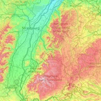
Name: Black Forest topographic map, elevation, terrain.
Location: Black Forest, Baden-Württemberg, Germany (47.55950 7.66408 48.97090 8.81081)
Average elevation: 471 m
Minimum elevation: 107 m
Maximum elevation: 1,468 m
Make a donation
Gear up for your next adventure:
As an Amazon Associate, this site earns from qualifying purchases at no extra cost to you.
Other topographic maps
Click on a map to view its topography, its elevation and its terrain.
Lauterbad
Germany > Baden-Württemberg > Landkreis Freudenstadt > Freudenstadt > Dietersweiler
Average elevation: 702 m
Lützenhardt
Germany > Baden-Württemberg > Landkreis Freudenstadt > Waldachtal
Average elevation: 615 m
Make a donation
Gear up for your next adventure:
As an Amazon Associate, this site earns from qualifying purchases at no extra cost to you.
Hollerbach
Germany > Baden-Württemberg > Neckar-Odenwald-Kreis > Buchen (Odenwald)
Average elevation: 395 m
Make a donation
Gear up for your next adventure:
As an Amazon Associate, this site earns from qualifying purchases at no extra cost to you.