
Thank you for supporting this site ❤️
Make a donation
Make a donation
Gear up for your next adventure:
As an Amazon Associate, this site earns from qualifying purchases at no extra cost to you.
Mapleton topographic map
Click on the map to display elevation.
Thank you for supporting this site ❤️
Make a donation
Make a donation
Gear up for your next adventure:
As an Amazon Associate, this site earns from qualifying purchases at no extra cost to you.
About this map
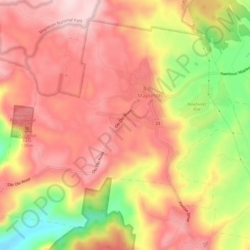
Name: Mapleton topographic map, elevation, terrain.
Location: Mapleton, Sunshine Coast Regional, Queensland, Australia (-26.64876 152.83418 -26.61043 152.88532)
Average elevation: 333 m
Minimum elevation: 128 m
Maximum elevation: 455 m
Thank you for supporting this site ❤️
Make a donation
Make a donation
Gear up for your next adventure:
As an Amazon Associate, this site earns from qualifying purchases at no extra cost to you.
Other topographic maps
Click on a map to view its topography, its elevation and its terrain.
Koala Park Bushland Conservation Reserve
Australia > Queensland > Sunshine Coast Regional > Nambour
Average elevation: 35 m