
Make a donation
Gear up for your next adventure:
As an Amazon Associate, this site earns from qualifying purchases at no extra cost to you.
Pass Lake topographic map
Click on the map to display elevation.
Make a donation
Gear up for your next adventure:
As an Amazon Associate, this site earns from qualifying purchases at no extra cost to you.
About this map
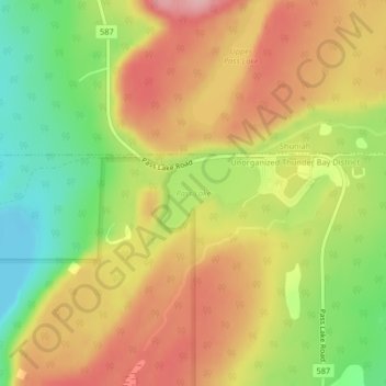
Name: Pass Lake topographic map, elevation, terrain.
Average elevation: 259 m
Minimum elevation: 179 m
Maximum elevation: 327 m
Make a donation
Gear up for your next adventure:
As an Amazon Associate, this site earns from qualifying purchases at no extra cost to you.
Other topographic maps
Click on a map to view its topography, its elevation and its terrain.
Shebandowan
Canada > Ontario > Thunder Bay District > Unorganized Thunder Bay District
Average elevation: 461 m
Whitefish Lake
Canada > Ontario > Thunder Bay District > Unorganized Thunder Bay District
Average elevation: 472 m
Sunbow Lake
Canada > Ontario > Thunder Bay District > Unorganized Thunder Bay District
Average elevation: 491 m
Sulphur Lake
Canada > Ontario > Thunder Bay District > Unorganized Thunder Bay District
Average elevation: 467 m
Make a donation
Gear up for your next adventure:
As an Amazon Associate, this site earns from qualifying purchases at no extra cost to you.
Tower Mountain
Canada > Ontario > Thunder Bay District > Unorganized Thunder Bay District
Average elevation: 575 m
Trowbridge Island
Canada > Ontario > Thunder Bay District > Unorganized Thunder Bay District
Average elevation: 179 m
Joyce Lake
Canada > Ontario > Thunder Bay District > Unorganized Thunder Bay District
Average elevation: 391 m
Upsala
Canada > Ontario > Thunder Bay District > Unorganized Thunder Bay District
Average elevation: 487 m
Make a donation
Gear up for your next adventure:
As an Amazon Associate, this site earns from qualifying purchases at no extra cost to you.
Tomlinson Lake
Canada > Ontario > Thunder Bay District > Unorganized Thunder Bay District
Average elevation: 489 m
Sunshine
Canada > Ontario > Thunder Bay District > Unorganized Thunder Bay District
Average elevation: 401 m
Ara Lake
Canada > Ontario > Thunder Bay District > Unorganized Thunder Bay District
Average elevation: 308 m
Paint Lake
Canada > Ontario > Thunder Bay District > Unorganized Thunder Bay District
Average elevation: 450 m
Make a donation
Gear up for your next adventure:
As an Amazon Associate, this site earns from qualifying purchases at no extra cost to you.
O'Brien Lake
Canada > Ontario > Thunder Bay District > Unorganized Thunder Bay District
Average elevation: 205 m
Timmus Lake
Canada > Ontario > Thunder Bay District > Unorganized Thunder Bay District
Average elevation: 461 m
Shabaqua Corners
Canada > Ontario > Thunder Bay District > Unorganized Thunder Bay District
Average elevation: 416 m
Rossport
Canada > Ontario > Thunder Bay District > Unorganized Thunder Bay District
Average elevation: 227 m
Make a donation
Gear up for your next adventure:
As an Amazon Associate, this site earns from qualifying purchases at no extra cost to you.
Springpole Island
Canada > Ontario > Thunder Bay District > Unorganized Thunder Bay District
Average elevation: 289 m
Cola Creek
Canada > Ontario > Thunder Bay District > Unorganized Thunder Bay District
Average elevation: 479 m
Nolalu
Canada > Ontario > Thunder Bay District > Unorganized Thunder Bay District
Average elevation: 370 m
Squash Lake
Canada > Ontario > Thunder Bay District > Unorganized Thunder Bay District
Average elevation: 348 m
Make a donation
Gear up for your next adventure:
As an Amazon Associate, this site earns from qualifying purchases at no extra cost to you.
Topaz Lake
Canada > Ontario > Thunder Bay District > Unorganized Thunder Bay District
Average elevation: 482 m
Rossport
Canada > Ontario > Thunder Bay District > Unorganized Thunder Bay District
Average elevation: 227 m