
Liepaja topographic map
Interactive map
Click on the map to display elevation.
About this map
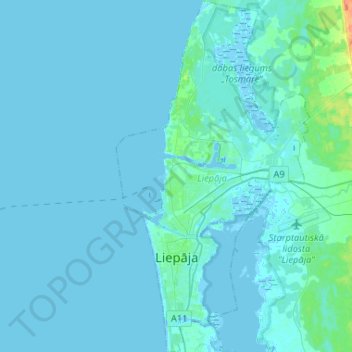
Name: Liepaja topographic map, elevation, terrain.
Location: Liepaja, Courland, Latvia (56.46531 20.96212 56.60905 21.10574)
Average elevation: 2 m
Minimum elevation: -3 m
Maximum elevation: 34 m
Other topographic maps
Click on a map to view its topography, its elevation and its terrain.
Jaunupe
Latvia > Courland > Ventspils novads > Tārgales pagasts
Jaunupe, Tārgales pagasts, Ventspils novads, Courland, Latvia
Average elevation: 7 m
Valdeķi
Latvia > Courland > Tukuma novads > Kandavas pagasts
Valdeķi, Kandavas pagasts, Tukuma novads, Courland, Latvia
Average elevation: 63 m
Kuldīga
Latvia > Courland > Kuldīgas novads > Kuldīga
Kuldīga, Kuldīgas novads, Courland, LV-3301, Latvia
Average elevation: 38 m