
Thank you for supporting this site ❤️
Make a donation
Make a donation
Gear up for your next adventure:
As an Amazon Associate, this site earns from qualifying purchases at no extra cost to you.
Frutillas topographic map
Click on the map to display elevation.
Thank you for supporting this site ❤️
Make a donation
Make a donation
Gear up for your next adventure:
As an Amazon Associate, this site earns from qualifying purchases at no extra cost to you.
About this map
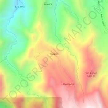
Name: Frutillas topographic map, elevation, terrain.
Location: Frutillas, Nono, Quito Canton, Pichincha, Ecuador (-0.10699 -78.61347 -0.06699 -78.57347)
Average elevation: 2,977 m
Minimum elevation: 2,455 m
Maximum elevation: 3,525 m
Thank you for supporting this site ❤️
Make a donation
Make a donation
Gear up for your next adventure:
As an Amazon Associate, this site earns from qualifying purchases at no extra cost to you.