
Hart County topographic map
Interactive map
Click on the map to display elevation.
About this map
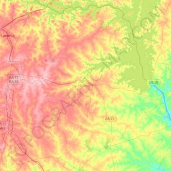
Name: Hart County topographic map, elevation, terrain.
Location: Hart County, Georgia, United States of America (34.21016 -83.11585 34.49376 -82.77406)
Average elevation: 225 m
Minimum elevation: 144 m
Maximum elevation: 296 m
Other topographic maps
Click on a map to view its topography, its elevation and its terrain.
Murray County
United States of America > Georgia
Murray County, Georgia, United States of America
Average elevation: 381 m
Americus
United States of America > Georgia > Americus
Americus, Sumter County, Georgia, 31709, United States of America
Average elevation: 125 m
Coffee County
United States of America > Georgia
Coffee County, Georgia, United States of America
Average elevation: 72 m
Poetry
United States of America > Georgia > Poetry
Poetry, Chattooga County, Georgia, United States of America
Average elevation: 277 m
Ben Hill County
United States of America > Georgia
Ben Hill County, Georgia, 31750, United States of America
Average elevation: 88 m
Towns County
United States of America > Georgia
Towns County, Georgia, United States of America
Average elevation: 764 m