
Make a donation
Gear up for your next adventure:
As an Amazon Associate, this site earns from qualifying purchases at no extra cost to you.
Mono Lake topographic map
Click on the map to display elevation.
Make a donation
Gear up for your next adventure:
As an Amazon Associate, this site earns from qualifying purchases at no extra cost to you.
Mono Lake
Lake Russell was the prehistoric predecessor to Mono Lake, during the Pleistocene. Its shoreline reached the modern-day elevation of 7,480 feet (2,280 m), about 1,100 feet (330 m) higher than the present-day lake. As of 1.6 million years ago, Lake Russell discharged to the northeast, into the Walker River drainage. After the Long Valley Caldera eruption 760,000 years ago, Lake Russell discharged into Adobe Lake to the southeast, then into the Owens River, and eventually into Lake Manly in Death Valley. Prominent shore lines of Lake Russell, called strandlines by geologists, can be seen west of Mono Lake.
Make a donation
Gear up for your next adventure:
As an Amazon Associate, this site earns from qualifying purchases at no extra cost to you.
About this map
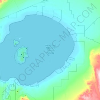
Name: Mono Lake topographic map, elevation, terrain.
Location: Mono Lake, Mono County, California, United States (37.94102 -119.14866 38.07480 -118.90942)
Average elevation: 2,008 m
Minimum elevation: 1,944 m
Maximum elevation: 2,535 m
Make a donation
Gear up for your next adventure:
As an Amazon Associate, this site earns from qualifying purchases at no extra cost to you.
Other topographic maps
Click on a map to view its topography, its elevation and its terrain.
June Lake
United States > California > Mono County
June Lake is an unincorporated community and census-designated place (CDP) in Mono County, California, United States. It is located against the southern rim of the Mono Basin, 12.5 miles (20 km) south of Lee Vining, at an elevation of 7,654 feet (2,333 m).
Average elevation: 2,548 m
Make a donation
Gear up for your next adventure:
As an Amazon Associate, this site earns from qualifying purchases at no extra cost to you.
Lee Vining
United States > California > Mono County
Lee Vining (formerly Leevining, Poverty Flat, and Lakeview) is an unincorporated community and census-designated place (CDP) in Mono County, California, United States. It is located 25 miles (40 km) south-southeast of Bridgeport, at an elevation of 6,781 feet (2,067 m). Lee Vining is located on the southwest…
Average elevation: 2,180 m
Make a donation
Gear up for your next adventure:
As an Amazon Associate, this site earns from qualifying purchases at no extra cost to you.
Mono Lake Tufa State Natural Reserve
United States > California > Mono County
Average elevation: 2,090 m
Make a donation
Gear up for your next adventure:
As an Amazon Associate, this site earns from qualifying purchases at no extra cost to you.
Make a donation
Gear up for your next adventure:
As an Amazon Associate, this site earns from qualifying purchases at no extra cost to you.