
Sort topographic map
Interactive map
Click on the map to display elevation.
About this map
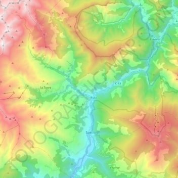
Name: Sort topographic map, elevation, terrain.
Location: Sort, Pallars Sobirá, Lérida, Cataluña, 25560, España (42.37007 1.01643 42.53092 1.20457)
Average elevation: 1,541 m
Minimum elevation: 653 m
Maximum elevation: 2,885 m
Other topographic maps
Click on a map to view its topography, its elevation and its terrain.
Enviny
España > Cataluña > Pallars Sobirá > Sort
Enviny, Sort, Pallars Sobirá, Lérida, Cataluña, 25560, España
Average elevation: 1,106 m