
Make a donation
Gear up for your next adventure:
As an Amazon Associate, this site earns from qualifying purchases at no extra cost to you.
Waldkönigen topographic map
Click on the map to display elevation.
Make a donation
Gear up for your next adventure:
As an Amazon Associate, this site earns from qualifying purchases at no extra cost to you.
About this map
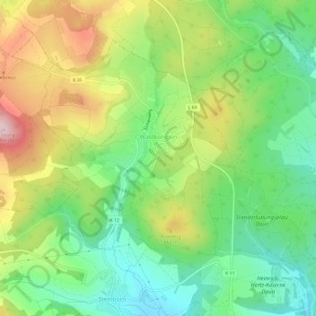
Name: Waldkönigen topographic map, elevation, terrain.
Average elevation: 529 m
Minimum elevation: 418 m
Maximum elevation: 696 m
Make a donation
Gear up for your next adventure:
As an Amazon Associate, this site earns from qualifying purchases at no extra cost to you.
Other topographic maps
Click on a map to view its topography, its elevation and its terrain.
Burg Daun
Deutschland > Rheinland-Pfalz > Landkreis Vulkaneifel > Daun
Die Burg Daun ist die Ruine einer Höhenburg in der Vulkaneifel. Sie war Stammburg der Herren zu Daun, zu Oberstein an der Nahe, zu Densborn bei Gerolstein, zu Bruch bei Wittlich und Zievel bei Euskirchen. Vor der Zeit der Dauner Herren und späteren Grafen war der Basalthügel vermutlich eine keltische…
Average elevation: 441 m