
Thank you for supporting this site ❤️
Make a donation
Make a donation
Gear up for your next adventure:
As an Amazon Associate, this site earns from qualifying purchases at no extra cost to you.
Bödele topographic map
Click on the map to display elevation.
Thank you for supporting this site ❤️
Make a donation
Make a donation
Gear up for your next adventure:
As an Amazon Associate, this site earns from qualifying purchases at no extra cost to you.
Bödele
Der Losenpass verbindet auf einer Meereshöhe von 1.139 Meter die Talschaften Rheintal und Bregenzerwald. Die höchste Erhebung im Bödelegebiet ist der Hochälpelekopf mit einer Höhe von 1464 m.
Thank you for supporting this site ❤️
Make a donation
Make a donation
Gear up for your next adventure:
As an Amazon Associate, this site earns from qualifying purchases at no extra cost to you.
About this map
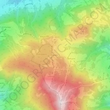
Name: Bödele topographic map, elevation, terrain.
Average elevation: 1,027 m
Minimum elevation: 621 m
Maximum elevation: 1,452 m
Thank you for supporting this site ❤️
Make a donation
Make a donation
Gear up for your next adventure:
As an Amazon Associate, this site earns from qualifying purchases at no extra cost to you.