
Thank you for supporting this site ❤️
Make a donation
Make a donation
Gear up for your next adventure:
As an Amazon Associate, this site earns from qualifying purchases at no extra cost to you.
Swords topographic map
Click on the map to display elevation.
Thank you for supporting this site ❤️
Make a donation
Make a donation
Gear up for your next adventure:
As an Amazon Associate, this site earns from qualifying purchases at no extra cost to you.
About this map
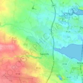
Name: Swords topographic map, elevation, terrain.
Location: Swords, Rowlestown, Fingal, County Dublin, Leinster, Ireland (53.43061 -6.28325 53.51397 -6.16905)
Average elevation: 26 m
Minimum elevation: -19 m
Maximum elevation: 80 m
County Dublin trails, hiking, mountain biking, running and outdoor activities
Thank you for supporting this site ❤️
Make a donation
Make a donation
Gear up for your next adventure:
As an Amazon Associate, this site earns from qualifying purchases at no extra cost to you.