Dundee topographic map
Click on the map to display elevation.
Dundee
Dundee sits on the north bank of the Firth of Tay on the eastern, North Sea Coast of Scotland. The city lies 36.1 miles (58 km) NNE of Edinburgh and 360.6 miles (580 km) NNW of London. The built-up area occupies a roughly rectangular shape 8.3 miles (13 km) long by 2.5 miles (4 km) wide, aligned in an east to west direction and occupies an area of 60 square kilometres (23 sq mi). The town is bisected by a line of hills stretching from Balgay Hill (elevation of 143 m) in the west end of the city, through the Dundee Law (174 m) which occupies the centre of the built up area, to Gallow Hill (83 m), between Baxter Park and the Eastern Cemetery. North of this ridge lies a valley through which cuts the Dighty Water burn, the elevation falling to around 45 m. North of the Dighty valley lie the Sidlaw Hills, the most prominent hill being Craigowl Hill (455 m).
About this map
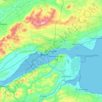
Name: Dundee topographic map, elevation, terrain.
Location: Dundee, Dundee City, Scotland, DD1 3BZ, United Kingdom (56.30059 -3.13019 56.62059 -2.81019)
Average elevation: 82 m
Minimum elevation: -1 m
Maximum elevation: 449 m
Other topographic maps
Click on a map to view its topography, its elevation and its terrain.