
Make a donation
Gear up for your next adventure:
As an Amazon Associate, this site earns from qualifying purchases at no extra cost to you.
Brinkley topographic map
Click on the map to display elevation.
Make a donation
Gear up for your next adventure:
As an Amazon Associate, this site earns from qualifying purchases at no extra cost to you.
About this map
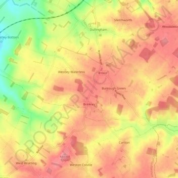
Name: Brinkley topographic map, elevation, terrain.
Average elevation: 97 m
Minimum elevation: 42 m
Maximum elevation: 130 m
Make a donation
Gear up for your next adventure:
As an Amazon Associate, this site earns from qualifying purchases at no extra cost to you.
Other topographic maps
Click on a map to view its topography, its elevation and its terrain.
River Great Ouse or Ely Ouse
United Kingdom > England > Cambridgeshire > East Cambridgeshire > Soham > Stuntney
Average elevation: 4 m
Holme Fen
United Kingdom > England > Cambridgeshire > East Cambridgeshire > Haddenham
Average elevation: 4 m
Little Ouse
United Kingdom > England > Cambridgeshire > East Cambridgeshire > Littleport
Average elevation: -1 m
Make a donation
Gear up for your next adventure:
As an Amazon Associate, this site earns from qualifying purchases at no extra cost to you.
Rack Fen
United Kingdom > England > Cambridgeshire > East Cambridgeshire > Littleport
Average elevation: 0 m
Make a donation
Gear up for your next adventure:
As an Amazon Associate, this site earns from qualifying purchases at no extra cost to you.
Little Thetford
United Kingdom > England > Cambridgeshire > East Cambridgeshire
Average elevation: 5 m
Chippenham Fen NNR (permit access)
United Kingdom > England > Cambridgeshire > East Cambridgeshire
Average elevation: 17 m
Make a donation
Gear up for your next adventure:
As an Amazon Associate, this site earns from qualifying purchases at no extra cost to you.
Little Thetford
United Kingdom > England > Cambridgeshire > East Cambridgeshire
Average elevation: 5 m
Witcham Toll
United Kingdom > England > Cambridgeshire > East Cambridgeshire > Witcham
Average elevation: 10 m
Make a donation
Gear up for your next adventure:
As an Amazon Associate, this site earns from qualifying purchases at no extra cost to you.