
Make a donation
Gear up for your next adventure:
As an Amazon Associate, this site earns from qualifying purchases at no extra cost to you.
Grad Nova Gradiška topographic map
Click on the map to display elevation.
Make a donation
Gear up for your next adventure:
As an Amazon Associate, this site earns from qualifying purchases at no extra cost to you.
About this map
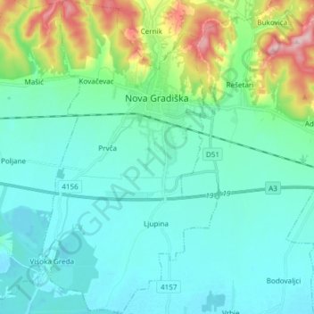
Name: Grad Nova Gradiška topographic map, elevation, terrain.
Location: Grad Nova Gradiška, Brod-Posavina County, 35400, Croatia (45.18744 17.32770 45.29263 17.41197)
Average elevation: 131 m
Minimum elevation: 89 m
Maximum elevation: 298 m
Make a donation
Gear up for your next adventure:
As an Amazon Associate, this site earns from qualifying purchases at no extra cost to you.
Other topographic maps
Click on a map to view its topography, its elevation and its terrain.
Staro Petrovo Selo
Croatia > Brod-Posavina County
It is located between the southern slopes of the Požeška gora mountain and the Sava river plain in the region of Slavonia, 12 km (7.5 mi) southeast of Nova Gradiška, at an elevation of 91 m.
Average elevation: 128 m