
Make a donation
Gear up for your next adventure:
As an Amazon Associate, this site earns from qualifying purchases at no extra cost to you.
Fiumefreddo Bruzio topographic map
Click on the map to display elevation.
Make a donation
Gear up for your next adventure:
As an Amazon Associate, this site earns from qualifying purchases at no extra cost to you.
About this map
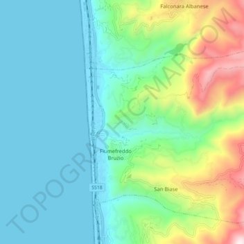
Name: Fiumefreddo Bruzio topographic map, elevation, terrain.
Location: Fiumefreddo Bruzio, Cosenza, Kalabrien, Italien (39.21574 16.05619 39.27152 16.14356)
Average elevation: 228 m
Minimum elevation: 0 m
Maximum elevation: 996 m
Make a donation
Gear up for your next adventure:
As an Amazon Associate, this site earns from qualifying purchases at no extra cost to you.
Other topographic maps
Click on a map to view its topography, its elevation and its terrain.
Rossano
Italien > Kalabrien > Cosenza > Corigliano-Rossano
Rossano liegt am Ionischen Meer, in den nördlichen Ausläufern der Sila Greca. Das historische Zentrum befindet sich in etwa 275 Metern Höhe, am Fuß des Hangs liegt der moderne Stadtteil Rossano Scalò, der Stadtteil an der Küste heißt Lido Sant’Angelo und ist ein stark frequentierter Badeort.
Average elevation: 265 m
Make a donation
Gear up for your next adventure:
As an Amazon Associate, this site earns from qualifying purchases at no extra cost to you.