
Thank you for supporting this site ❤️
Make a donation
Make a donation
Gear up for your next adventure:
As an Amazon Associate, this site earns from qualifying purchases at no extra cost to you.
Chexbres topographic map
Click on the map to display elevation.
Thank you for supporting this site ❤️
Make a donation
Make a donation
Gear up for your next adventure:
As an Amazon Associate, this site earns from qualifying purchases at no extra cost to you.
About this map
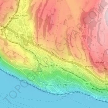
Name: Chexbres topographic map, elevation, terrain.
Location: Chexbres, District de Lavaux-Oron, Vaud, 1071, Switzerland (46.47453 6.76298 46.49360 6.79081)
Average elevation: 579 m
Minimum elevation: 367 m
Maximum elevation: 796 m
Thank you for supporting this site ❤️
Make a donation
Make a donation
Gear up for your next adventure:
As an Amazon Associate, this site earns from qualifying purchases at no extra cost to you.