
Make a donation
Gear up for your next adventure:
As an Amazon Associate, this site earns from qualifying purchases at no extra cost to you.
Langford topographic map
Click on the map to display elevation.
Make a donation
Gear up for your next adventure:
As an Amazon Associate, this site earns from qualifying purchases at no extra cost to you.
About this map
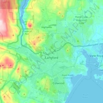
Name: Langford topographic map, elevation, terrain.
Average elevation: 116 m
Minimum elevation: -1 m
Maximum elevation: 541 m
Make a donation
Gear up for your next adventure:
As an Amazon Associate, this site earns from qualifying purchases at no extra cost to you.
Other topographic maps
Click on a map to view its topography, its elevation and its terrain.
Lone Tree Hill
Canada > British Columbia > Capital Regional District > Highlands
Average elevation: 229 m
Port Renfrew
Canada > British Columbia > Capital Regional District > Juan de Fuca Electoral Area
Average elevation: 78 m
Make a donation
Gear up for your next adventure:
As an Amazon Associate, this site earns from qualifying purchases at no extra cost to you.
Leechtown
Canada > British Columbia > Capital Regional District > Juan de Fuca Electoral Area
Average elevation: 237 m
San Juan River
Canada > British Columbia > Capital Regional District > Juan de Fuca Electoral Area
Average elevation: 37 m
Shirley
Canada > British Columbia > Capital Regional District > Juan de Fuca Electoral Area
Average elevation: 79 m
San Juan Ridge
Canada > British Columbia > Capital Regional District > Juan de Fuca Electoral Area
Average elevation: 841 m
Make a donation
Gear up for your next adventure:
As an Amazon Associate, this site earns from qualifying purchases at no extra cost to you.
Saanich Peninsula
Canada > British Columbia > Capital Regional District > Central Saanich
Average elevation: 49 m
Saanich
Canada > British Columbia > Capital Regional District > Saanich > Saanich
Average elevation: 32 m
View Royal
Canada > British Columbia > Capital Regional District > View Royal > View Royal
Average elevation: 34 m
Make a donation
Gear up for your next adventure:
As an Amazon Associate, this site earns from qualifying purchases at no extra cost to you.
Fulford Harbour
Canada > British Columbia > Capital Regional District > Salt Spring Island Electoral Area
Average elevation: 110 m
PKOLS (Mount Douglas)
Canada > British Columbia > Capital Regional District > Saanich
Average elevation: 47 m
Mount Finlayson
Canada > British Columbia > Capital Regional District > Langford
Average elevation: 158 m
Japan Gulch Reservoir
Canada > British Columbia > Capital Regional District > Juan de Fuca Electoral Area
Average elevation: 274 m
Make a donation
Gear up for your next adventure:
As an Amazon Associate, this site earns from qualifying purchases at no extra cost to you.
Mayne
Canada > British Columbia > Capital Regional District > Southern Gulf Islands Electoral Area
Average elevation: 52 m
Goldstream River
Canada > British Columbia > Capital Regional District > Juan de Fuca Electoral Area
Average elevation: 247 m
Cecelia Creek Falls Park
Canada > British Columbia > Capital Regional District > Saanich
Average elevation: 36 m
Mount Parke
Canada > British Columbia > Capital Regional District > Southern Gulf Islands Electoral Area
Average elevation: 74 m
Make a donation
Gear up for your next adventure:
As an Amazon Associate, this site earns from qualifying purchases at no extra cost to you.
Abraham Collins' Lookout
Canada > British Columbia > Capital Regional District > North Saanich
Average elevation: 149 m
Young Lake
Canada > British Columbia > Capital Regional District > Juan de Fuca Electoral Area
Average elevation: 138 m
Crow's Nest
Canada > British Columbia > Capital Regional District > Metchosin
Average elevation: 305 m
Ganges
Canada > British Columbia > Capital Regional District > Salt Spring Island Electoral Area
Average elevation: 113 m
Make a donation
Gear up for your next adventure:
As an Amazon Associate, this site earns from qualifying purchases at no extra cost to you.
Esquimalt
Canada > British Columbia > Capital Regional District > Esquimalt > Esquimalt
Average elevation: 14 m
Triangular Hill
Canada > British Columbia > Capital Regional District > Colwood
Average elevation: 108 m
Make a donation
Gear up for your next adventure:
As an Amazon Associate, this site earns from qualifying purchases at no extra cost to you.
Mayne
Canada > British Columbia > Capital Regional District > Southern Gulf Islands Electoral Area
Average elevation: 52 m
Mayne
Canada > British Columbia > Capital Regional District > Southern Gulf Islands Electoral Area
Average elevation: 52 m