
Kosivska Poliana topographic map
Interactive map
Click on the map to display elevation.
About this map
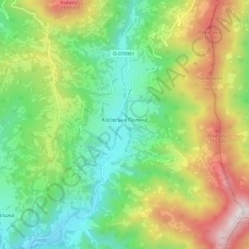
Name: Kosivska Poliana topographic map, elevation, terrain.
Average elevation: 733 m
Minimum elevation: 358 m
Maximum elevation: 1,386 m
Other topographic maps
Click on a map to view its topography, its elevation and its terrain.
Ancient and Primeval Beech Forests of the Carpathians and Other Regions of Europe
Ancient and Primeval Beech Forests of the Carpathians and Other Regions of Europe, Rakhiv Raion, Zakarpattia Oblast, Ukraine
Average elevation: 467 m
Hoverla
Hoverla, Rakhiv Raion, Zakarpattia Oblast, Ukraine
Average elevation: 1,667 m