
Gegharkunik Province topographic map
Interactive map
Click on the map to display elevation.
About this map
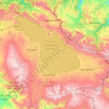
Name: Gegharkunik Province topographic map, elevation, terrain.
Location: Gegharkunik Province, Armenia (39.87198 44.77966 40.74022 45.97991)
Average elevation: 2,141 m
Minimum elevation: 900 m
Maximum elevation: 3,536 m
Other topographic maps
Click on a map to view its topography, its elevation and its terrain.
Zovuni
Zovuni, Yeghvard region, Kotayk Province, Armenia
Average elevation: 1,194 m
Gyumri
Armenia > Shirak Province > Gyumri
Gyumri, Akhuryan region, Shirak Province, Armenia
Average elevation: 1,535 m