
Make a donation
Gear up for your next adventure:
As an Amazon Associate, this site earns from qualifying purchases at no extra cost to you.
Kindia Region topographic map
Click on the map to display elevation.
Make a donation
Gear up for your next adventure:
As an Amazon Associate, this site earns from qualifying purchases at no extra cost to you.
About this map
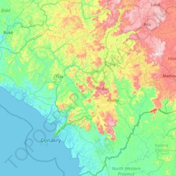
Name: Kindia Region topographic map, elevation, terrain.
Location: Kindia Region, Guinea (9.03412 -14.01236 11.38009 -12.11009)
Average elevation: 259 m
Minimum elevation: -1 m
Maximum elevation: 1,401 m
Make a donation
Gear up for your next adventure:
As an Amazon Associate, this site earns from qualifying purchases at no extra cost to you.
Other topographic maps
Click on a map to view its topography, its elevation and its terrain.
Pita
Guinea > Mamou Region > Pita Prefecture
Th geographical coordinates of the town are 11°03'16.0"N, 12°23'46.0"W (Latitude:11.054444; Longitude:-12.396111). The town is located at an average elevation of 972.6 metres (3,191 ft) above mean sea level.
Average elevation: 937 m