
Make a donation
Gear up for your next adventure:
As an Amazon Associate, this site earns from qualifying purchases at no extra cost to you.
Abuja topographic map
Click on the map to display elevation.
Make a donation
Gear up for your next adventure:
As an Amazon Associate, this site earns from qualifying purchases at no extra cost to you.
Abuja
The elevation is 360 metres (1,180 ft).
Make a donation
Gear up for your next adventure:
As an Amazon Associate, this site earns from qualifying purchases at no extra cost to you.
About this map
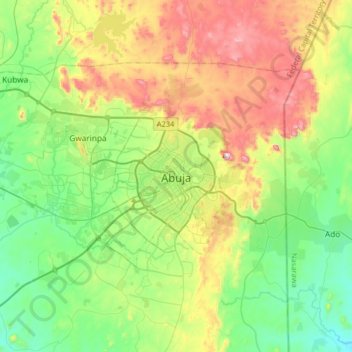
Name: Abuja topographic map, elevation, terrain.
Average elevation: 508 m
Minimum elevation: 291 m
Maximum elevation: 927 m
Make a donation
Gear up for your next adventure:
As an Amazon Associate, this site earns from qualifying purchases at no extra cost to you.
Other topographic maps
Click on a map to view its topography, its elevation and its terrain.
Gwarinpa
Nigeria > Federal Capital Territory > Municipal Area Council > Gwarinpa
Average elevation: 471 m
Central Business District
Nigeria > Federal Capital Territory > Municipal Area Council
Average elevation: 494 m
Make a donation
Gear up for your next adventure:
As an Amazon Associate, this site earns from qualifying purchases at no extra cost to you.
Central Business District
Nigeria > Federal Capital Territory > Municipal Area Council
Average elevation: 494 m
Gwarinpa
Nigeria > Federal Capital Territory > Municipal Area Council > Gwarinpa
Average elevation: 471 m
Make a donation
Gear up for your next adventure:
As an Amazon Associate, this site earns from qualifying purchases at no extra cost to you.
Central Business District
Nigeria > Federal Capital Territory > Municipal Area Council
Average elevation: 494 m
Make a donation
Gear up for your next adventure:
As an Amazon Associate, this site earns from qualifying purchases at no extra cost to you.
Jabi Reservoir
Nigeria > Federal Capital Territory > Municipal Area Council > Jabi
Average elevation: 450 m