
Seward County topographic map
Interactive map
Click on the map to display elevation.
About this map
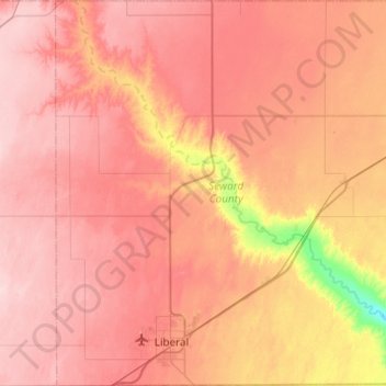
Name: Seward County topographic map, elevation, terrain.
Location: Seward County, Kansas, United States of America (36.99795 -101.06811 37.38805 -100.63328)
Average elevation: 866 m
Minimum elevation: 750 m
Maximum elevation: 928 m
Other topographic maps
Click on a map to view its topography, its elevation and its terrain.
Lawrence
United States of America > Kansas > Lawrence
Lawrence, Douglas County, Kansas, United States of America
Average elevation: 265 m
Pottawatomie County
United States of America > Kansas
Pottawatomie County, Kansas, United States of America
Average elevation: 367 m
Greenwood County
United States of America > Kansas
Greenwood County, Kansas, United States of America
Average elevation: 372 m