
Parigi topographic map
Interactive map
Click on the map to display elevation.
About this map
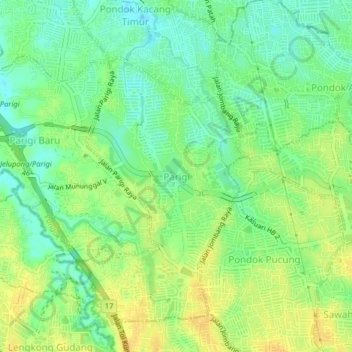
Name: Parigi topographic map, elevation, terrain.
Location: Parigi, Tangerang Selatan, Banten, Jawa, 15227, Indonesien (-6.29275 106.67958 -6.25275 106.71958)
Average elevation: 31 m
Minimum elevation: 18 m
Maximum elevation: 43 m
Other topographic maps
Click on a map to view its topography, its elevation and its terrain.
Bendungan gintung ( Situ Gintung )
Indonesien > Banten > Tangerang Selatan > Cireundeu
Bendungan gintung ( Situ Gintung ), Jalan Gunung Indah IV, RT 04, RW 11, Cireundeu, Tangerang Selatan, Banten, 15411, Indonesien
Average elevation: 44 m