
Make a donation
Gear up for your next adventure:
As an Amazon Associate, this site earns from qualifying purchases at no extra cost to you.
León topographic map
Click on the map to display elevation.
Make a donation
Gear up for your next adventure:
As an Amazon Associate, this site earns from qualifying purchases at no extra cost to you.
León
As for the temperatures, in general it is a cold climate due to the altitude and the abundance of frost (which persist from November to May), being more intense in the mountainous areas reaching -18 °C. Vega de Liordes, an enclave in the León sector of Picos de Europa belonging to the municipality of Posada de Valdeón registered −35.8 °C (−32.4 °F) on January 7, 2021.
Make a donation
Gear up for your next adventure:
As an Amazon Associate, this site earns from qualifying purchases at no extra cost to you.
About this map
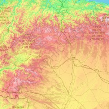
Name: León topographic map, elevation, terrain.
Location: León, Castile and León, Spain (42.02928 -7.07707 43.23820 -4.73236)
Average elevation: 913 m
Minimum elevation: 0 m
Maximum elevation: 2,527 m
Make a donation
Gear up for your next adventure:
As an Amazon Associate, this site earns from qualifying purchases at no extra cost to you.
Other topographic maps
Click on a map to view its topography, its elevation and its terrain.