
Bondowoso topographic map
Interactive map
Click on the map to display elevation.
About this map
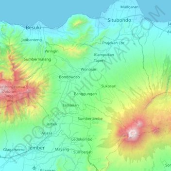
Name: Bondowoso topographic map, elevation, terrain.
Location: Bondowoso, Oost-Java, Indonesië (-8.13381 113.62326 -7.75652 114.24879)
Average elevation: 554 m
Minimum elevation: 0 m
Maximum elevation: 3,285 m
Other topographic maps
Click on a map to view its topography, its elevation and its terrain.
Gunung Bromo
Indonesië > Oost-Java > Pasuruan
Gunung Bromo, Pasuruan, Oost-Java, Indonesië
Average elevation: 2,239 m
Gunung Merapi
Indonesië > Oost-Java > Banjoewangi
Gunung Merapi, Banjoewangi, Oost-Java, Indonesië
Average elevation: 2,297 m
Kawah Bromo
Indonesië > Oost-Java > Probolinggo > Cemoro Lawang
Kawah Bromo, Road to Bromo, Cemoro Lawang, Probolinggo, Oost-Java, Indonesië
Average elevation: 2,250 m
Cemoro Lawang
Indonesië > Oost-Java > Probolinggo > Cemoro Lawang
Cemoro Lawang, Probolinggo, Oost-Java, Indonesië
Average elevation: 2,171 m