
Make a donation
Gear up for your next adventure:
As an Amazon Associate, this site earns from qualifying purchases at no extra cost to you.
Itatiba topographic map
Click on the map to display elevation.
Make a donation
Gear up for your next adventure:
As an Amazon Associate, this site earns from qualifying purchases at no extra cost to you.
Itatiba
Itatiba is a municipality in the state of São Paulo in Brazil, approximately 80 km from the State Capital. It is part of the Metropolitan Region of Campinas. The population in 2022 was 121 590 in an area of 322.269 km². The average elevation is 750 m. The place's name comes from the Tupi Guarani language, and means "Many Rocks". The city is known as the "Princess of the Hill" due to its rugged terrain. According to the Industry Federation of the State of Rio de Janeiro (FIRJAN), Itatiba was the ninth city with the highest quality of life in Brazil (fourth in the state of São Paulo), presenting a FIRJAN Municipal Development Index of 0.8779 in 2018. In the 1970s, it was used to known as the colonial-style furniture capital of Brazil. Itatiba also has one of the biggest thematic zoos in Latin America, the "Zooparque".
Make a donation
Gear up for your next adventure:
As an Amazon Associate, this site earns from qualifying purchases at no extra cost to you.
About this map
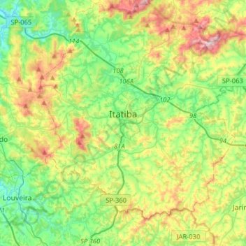
Name: Itatiba topographic map, elevation, terrain.
Average elevation: 802 m
Minimum elevation: 642 m
Maximum elevation: 1,113 m
Make a donation
Gear up for your next adventure:
As an Amazon Associate, this site earns from qualifying purchases at no extra cost to you.
Other topographic maps
Click on a map to view its topography, its elevation and its terrain.