
Make a donation
Gear up for your next adventure:
As an Amazon Associate, this site earns from qualifying purchases at no extra cost to you.
Dayton topographic map
Click on the map to display elevation.
Make a donation
Gear up for your next adventure:
As an Amazon Associate, this site earns from qualifying purchases at no extra cost to you.
Dayton
Dayton's climate features warm, muggy summers and cold, dry winters, and is classified as a humid continental climate (Köppen Dfa). Unless otherwise noted, all normal figures quoted within the text below are from the official climatology station, Dayton International Airport, at an elevation of 1,000 ft (304.8 m) about 10 mi (16 km) to the north of downtown Dayton, which lies within the valley of the Miami River; thus temperatures there are typically cooler than in downtown.
Make a donation
Gear up for your next adventure:
As an Amazon Associate, this site earns from qualifying purchases at no extra cost to you.
About this map
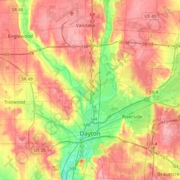
Name: Dayton topographic map, elevation, terrain.
Location: Dayton, Montgomery County, Ohio, United States (39.70185 -84.31138 39.92082 -84.09294)
Average elevation: 270 m
Minimum elevation: 212 m
Maximum elevation: 317 m
Make a donation
Gear up for your next adventure:
As an Amazon Associate, this site earns from qualifying purchases at no extra cost to you.