
Whitestone topographic map
Click on the map to display elevation.
About this map
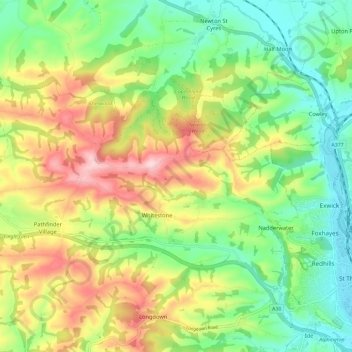
Name: Whitestone topographic map, elevation, terrain.
Average elevation: 104 m
Minimum elevation: 6 m
Maximum elevation: 250 m
Other topographic maps
Click on a map to view its topography, its elevation and its terrain.
Teignmouth Beach
United Kingdom > England > Devon > Teignbridge > Teignmouth > Shaldon
Average elevation: 24 m
Ponsworthy
United Kingdom > England > Devon > Teignbridge > Widecombe-in-the-Moor
Average elevation: 278 m
Heltor Rock
United Kingdom > England > Devon > Teignbridge > Bridford > Westcott
Average elevation: 249 m
Haytor Rocks
United Kingdom > England > Devon > Teignbridge > Haytor Vale > Smallacombe
Average elevation: 354 m
Greatoak Cross
United Kingdom > England > Devon > Teignbridge > Abbotskerswell > Whiddon
Average elevation: 58 m
Southbrook
United Kingdom > England > Devon > Teignbridge > Buckland in the Moor
Average elevation: 239 m
Bonehill
United Kingdom > England > Devon > Teignbridge > Widecombe in the Moor > Bonehill
Average elevation: 354 m
Holcombe Down
United Kingdom > England > Devon > Teignbridge > Teignmouth > Holcombe Down
Average elevation: 101 m
Lindridge Park
United Kingdom > England > Devon > Teignbridge > Luton > Humber
Average elevation: 125 m