
Thank you for supporting this site ❤️
Make a donation
Make a donation
Gear up for your next adventure:
As an Amazon Associate, this site earns from qualifying purchases at no extra cost to you.
Chemperi topographic map
Click on the map to display elevation.
Thank you for supporting this site ❤️
Make a donation
Make a donation
Gear up for your next adventure:
As an Amazon Associate, this site earns from qualifying purchases at no extra cost to you.
About this map
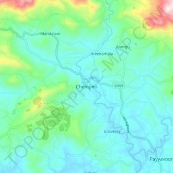
Name: Chemperi topographic map, elevation, terrain.
Location: Chemperi, Taliparamba, Kannur district, Kerala, 670632, India (12.05582 75.50711 12.13582 75.58711)
Average elevation: 137 m
Minimum elevation: 12 m
Maximum elevation: 652 m
Thank you for supporting this site ❤️
Make a donation
Make a donation
Gear up for your next adventure:
As an Amazon Associate, this site earns from qualifying purchases at no extra cost to you.