
Mieres topographic map
Interactive map
Click on the map to display elevation.
About this map
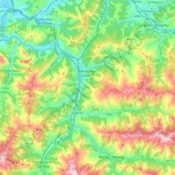
Name: Mieres topographic map, elevation, terrain.
Location: Mieres, Asturies, Espagne (43.18111 -5.85553 43.28914 -5.62549)
Average elevation: 498 m
Minimum elevation: 116 m
Maximum elevation: 1,171 m
Other topographic maps
Click on a map to view its topography, its elevation and its terrain.
El Vaḷḷitu / El Valletu
Espagne > Asturies > Mieres > Cuna
El Vaḷḷitu / El Valletu, Cuna, Mieres, Asturies, 33640, Espagne
Average elevation: 408 m
Les cases d'Efrén
Espagne > Asturies > Mieres > Mieres > Les cases d'Efrén
Les cases d'Efrén, Mieres, Asturies, 33618, Espagne
Average elevation: 374 m