
Make a donation
Gear up for your next adventure:
As an Amazon Associate, this site earns from qualifying purchases at no extra cost to you.
Relizane topographic map
Click on the map to display elevation.
Make a donation
Gear up for your next adventure:
As an Amazon Associate, this site earns from qualifying purchases at no extra cost to you.
About this map
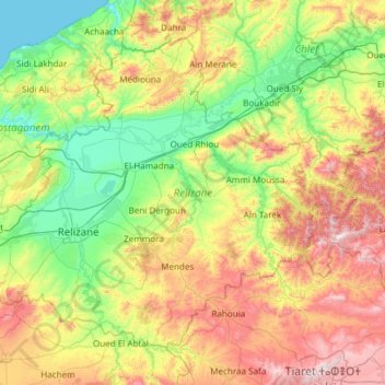
Name: Relizane topographic map, elevation, terrain.
Location: Relizane, Algeria (35.44465 0.22720 36.22803 1.42799)
Average elevation: 384 m
Minimum elevation: 0 m
Maximum elevation: 1,246 m
Make a donation
Gear up for your next adventure:
As an Amazon Associate, this site earns from qualifying purchases at no extra cost to you.
Other topographic maps
Click on a map to view its topography, its elevation and its terrain.
Algiers
Algeria > Algiers > Sidi M'Hamed District > Alger-Centre
Algiers was a walled city from the time of the deys until the close of the 19th century. The French, after their occupation of the city (1830), built a rampart, parapet and ditch, with two terminal forts, Bab Azoun باب عزون to the south and Bab-el-Oued اد to the north. The forts and part of the…
Average elevation: 45 m