
Palmas topographic map
Interactive map
Click on the map to display elevation.
About this map
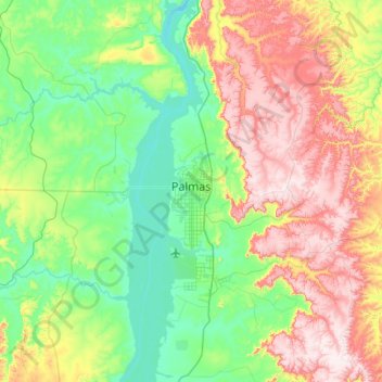
Name: Palmas topographic map, elevation, terrain.
Average elevation: 367 m
Minimum elevation: 189 m
Maximum elevation: 711 m
Palmas is located at the state's geographic centre at an average altitude of 230 m (755 ft). The city is located between the Serra do Lajeado hills on the east and the Tocantins River on the west. Palmas has a metropolitan area with 471,639 inhabitants.
Other topographic maps
Click on a map to view its topography, its elevation and its terrain.
Santa Maria do Tocantins
Brazil > Tocantins > Santa Maria do Tocantins
Santa Maria do Tocantins, Microrregião de Porto Nacional, Mesorregião Oriental do Tocantins, Tocantins, North Region, Brazil
Average elevation: 264 m