
Bakhuisbos topographic map
Interactive map
Click on the map to display elevation.
About this map
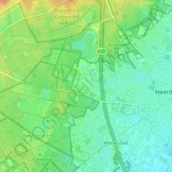
Name: Bakhuisbos topographic map, elevation, terrain.
Location: Bakhuisbos, Heerde, Gelderland, Nederland, 8181 NM, Nederland (52.37100 5.98904 52.41100 6.02904)
Average elevation: 18 m
Minimum elevation: 5 m
Maximum elevation: 41 m
Other topographic maps
Click on a map to view its topography, its elevation and its terrain.
Kolthoorn
Nederland > Gelderland > Heerde
Kolthoorn, Heerde, Gelderland, Nederland, 8181 NG, Nederland
Average elevation: 15 m
Hoorn
Nederland > Gelderland > Heerde > Hoorn
Hoorn, Heerde, Gelderland, Nederland, 8181, Nederland
Average elevation: 8 m