
Make a donation
Gear up for your next adventure:
As an Amazon Associate, this site earns from qualifying purchases at no extra cost to you.
Havixbeck topographic map
Click on the map to display elevation.
Make a donation
Gear up for your next adventure:
As an Amazon Associate, this site earns from qualifying purchases at no extra cost to you.
Havixbeck
Havixbeck is located on the fringes of the Baumberge, with 187 m the highest elevations of the Münsterland. West of the town emanates the spring of Münstersche Aa which, after passing Münster, converges in the Ems River near Greven.
Make a donation
Gear up for your next adventure:
As an Amazon Associate, this site earns from qualifying purchases at no extra cost to you.
About this map
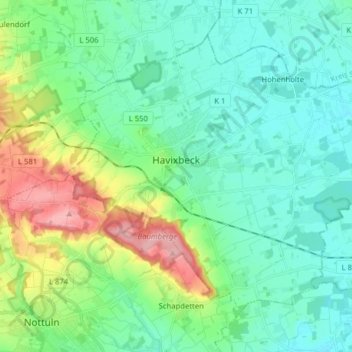
Name: Havixbeck topographic map, elevation, terrain.
Average elevation: 96 m
Minimum elevation: 63 m
Maximum elevation: 192 m
Make a donation
Gear up for your next adventure:
As an Amazon Associate, this site earns from qualifying purchases at no extra cost to you.